
This archive contains answers to questions sent to Unidata support through mid-2025. Note that the archive is no longer being updated. We provide the archive for reference; many of the answers presented here remain technically correct, even if somewhat outdated. For the most up-to-date information on the use of NSF Unidata software and data services, please consult the Software Documentation first.
Hi Kwan,
> Michael was able to help me correct the color problem
> in GEMPAK.
OK.
re:
> But I have to get back to you on the navigation problem that I
> reported earlier. I am sending you two gif files plotted using GEMPAK.
> The one on the left is the original image and the one on the right is after
> doing just a simple imgcopy.k TOPO/NEW MYDATA/IMAGES.3051 SIZE=ALL. One
> can clearly see that the map has been moved a noticeable distance to the
> southwest. This shift is also noted on the McIDAS plots you sent me.
If you recall, I noted that the original image's navigation seemed to
be shifted and that shift was maintained through both IMGCOPY and
IMGREMAP. I assumed that the reason for the shift had something to
do with how the original image was created, but I did not think more
about it after that.
re:
> Now I try something even more basic. I displayed the original file
> newustopo_hires.area with IMGDISP and saw that the navigation was off the
> same way after I ran IMGCOPY. But when I displayed the same file in
> GEMPAK, no such deviation was seen. This is puzzling.
Yes, it is puzzling to me why/how GEMPAK's navigation registration
seems to be better.
To satisfy my interest, I did the following to come up with an AREA
version of your original image in which the navigation registration
matches with discernible landmarks (e.g., Great Lakes, Great Salt
Lake, Florida coast):
DSSERVE LIST TEST
Group/Descriptor Type Format & Range RT Comment
------------------------ ----- ------------------ -- --------------------
TEST/TOPO IMAGE GINI Test TOPO from Kwan
DIRFILE=/home/mcidas/workdata/newustopo_hires.area
DSSERVE: done
IMGCOPY TEST/TOPO MYDATA/IMAGES.3049 SIZE=SAME
LWU LIST AREA3049 64 74
64. 538989392 -548 HEX: 20205350 FFFFFDDC ASCII: PS
66. 427 600000 HEX: 1AB 927C0 ASCII: '
68. 6036 1050000 HEX: 1794 100590 ASCII:
70. 6371200 0 HEX: 613780 0 ASCII: 7a
72. 0 0 HEX: 0 0 ASCII:
74. 900000 0 HEX: DBBA0 0 ASCII:
LWU POKE AREA3049 -552 65
LWU POKE AREA3049 428 66
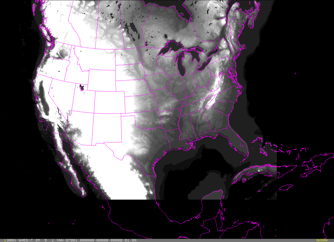
ERASE F;IMGDISP MYDATA/IMAGES.3049;MAP FILE=OUTVHPOL
EB <- adjust enhancement to accentuate landmarks
FRMSAVE 1 newustopo_hires_imgcopy.gif
I have attached the GIF screen capture (newusatopo._hires_imgcopy.gif) and
modified AREA file (AREA3049) to this email so you can see/use the results.
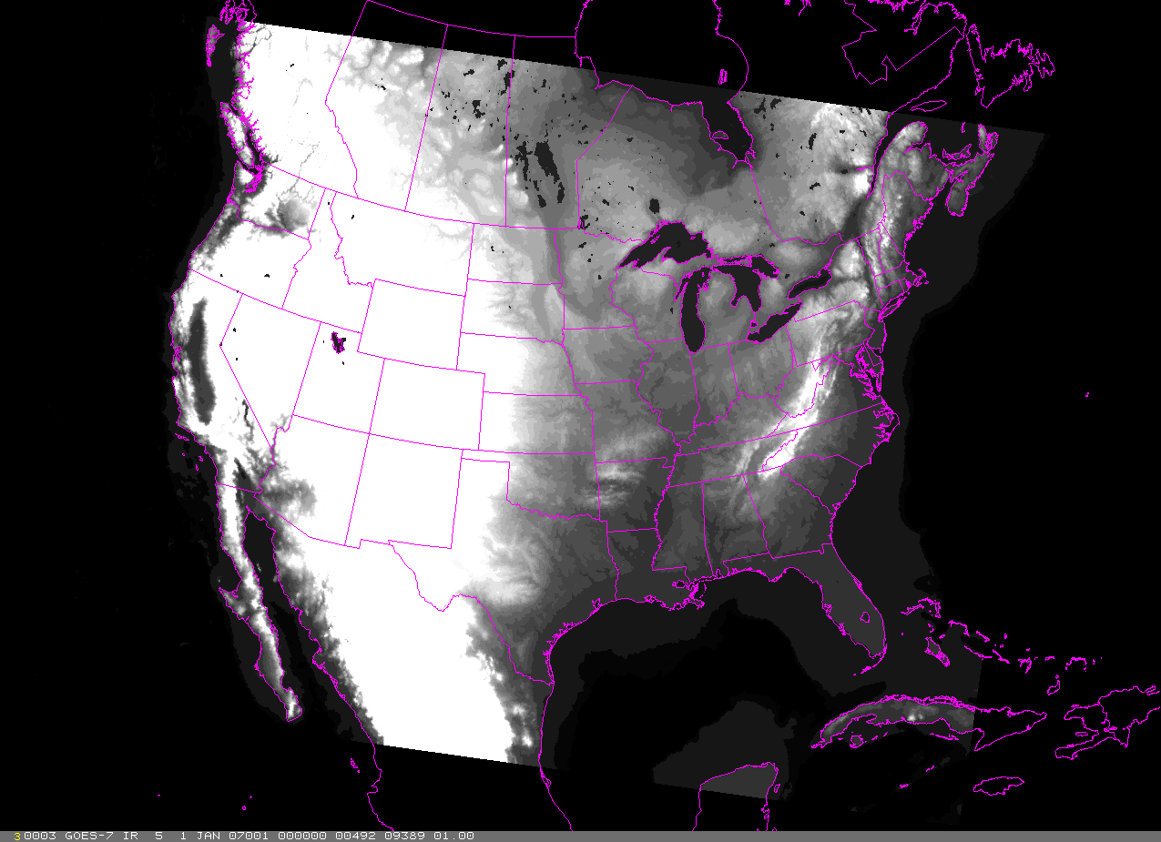
I then IMGREMAPped the file using:
IMGREMAP MYDATA/IMAGES.3049 MYDATA/IMAGES.3050 SSIZE=ALL PRO=PS X 97 SIZE=ALL
RES=6
and displayed the result using:
IMGDISP MYDATA/IMAGES.3050;MAP FILE=OUTVHPOL
EB <- adjust enhancement to accentuate landmarks
I have attached the resulting GIF (newusatopo_hires_imgremap.gif) and AREA file
(AREA3050) to this email so you can see/use the results.
Cheers,
Tom
--
****************************************************************************
Unidata User Support UCAR Unidata Program
(303) 497-8642 P.O. Box 3000
address@hidden Boulder, CO 80307
----------------------------------------------------------------------------
Unidata HomePage http://www.unidata.ucar.edu
****************************************************************************
Ticket Details
===================
Ticket ID: TEU-219455
Department: Support McIDAS
Priority: Normal
Status: ClosedAttachment:
newustopo_hires_imgcopy.gif
Description: GIF image
Attachment:
AREA3049
Description: Binary data
Attachment:
newustopo_hires_imgremap.gif
Description: GIF image
Attachment:
AREA3050
Description: Binary data