
This archive contains answers to questions sent to Unidata support through mid-2025. Note that the archive is no longer being updated. We provide the archive for reference; many of the answers presented here remain technically correct, even if somewhat outdated. For the most up-to-date information on the use of NSF Unidata software and data services, please consult the Software Documentation first.
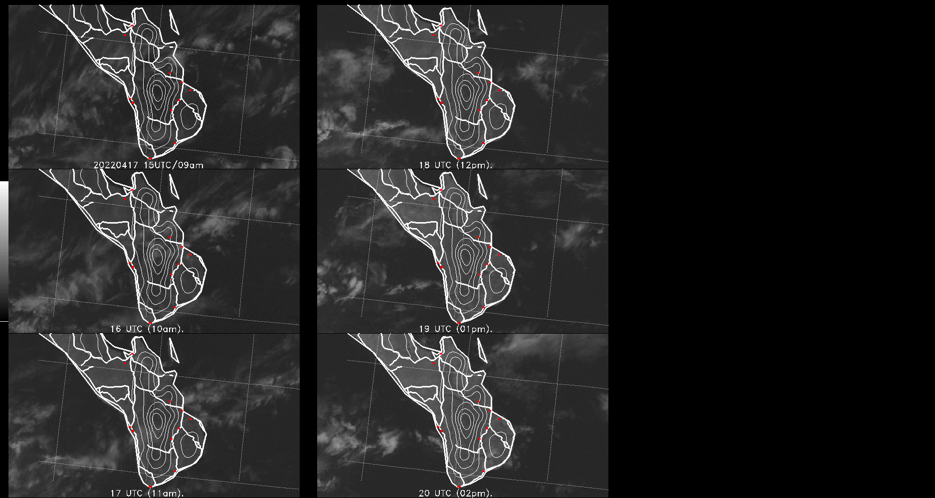
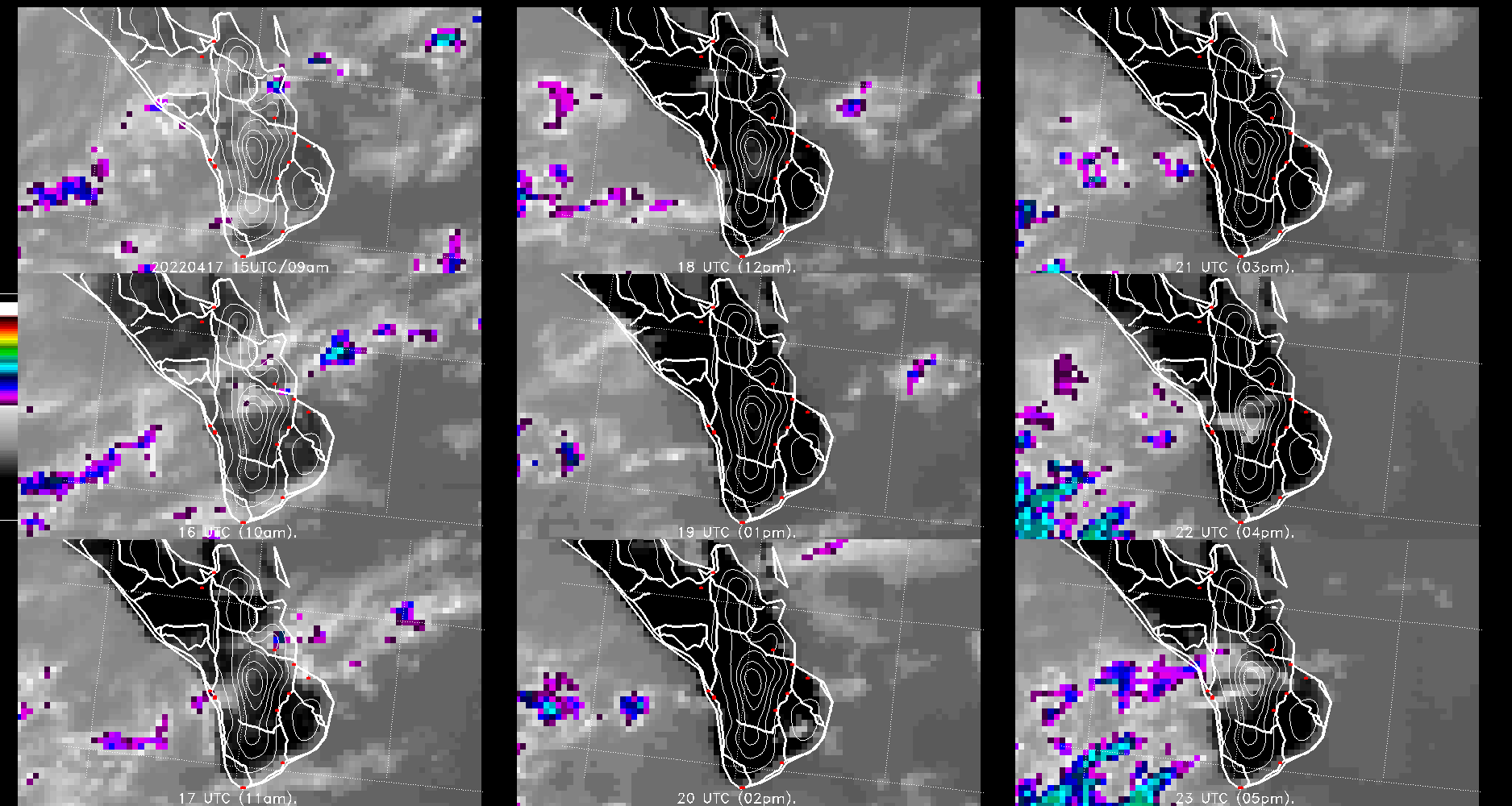
Luis, the images look great.  Glad it worked.

mj

> Michael,
> yes it works well for me, mainly the high-resolution map.
>
> These are a couple of example on how my new products look like:
> http://met-bcs.cicese.mx/satelite/diagram_vis.gif
> http://met-bcs.cicese.mx/satelite/diagram_ir2.gif
>
> This is the time of the year when convective systems develop
> in southern Baja California (23-25N) and having the roads is
> very useful to identify areas of potential damage. The above
> figure is updated every hour and red dots are the location
> of weather stations.
>
> Thank you,
> Luis M Farfan.
>
> > I've attached hi/med/lo-resolution mexico highway maps I created with
> > shpssf and ssfgsf.  shpcv was not required, but an edit to
> > $GEMPAK/includes/shpprm.h was necessary to increase MAXRECLEN, followed by
> > a re-compile of all libraries needed for the shpssf and ssfgsf builds.  So
> > rather than walk you through that process I've just attached the files I
> > produced and confirmed them with $mapfil in mapping programs.
> >
> > I'll add these to the next GEMPAK release with edits to the file names.
> >
> > Michael James
> > Unidata
> >
> >
> >
> >
> >> Michael,
> >> to confirm that I received, during the last few days, a couple of
> >> messages from you.
> >>
> >> I have a shapefile with the roads I am interested to convert into
> >> a gempak-readable format. However, using the shpcv program
> >> results in the following:
> >> $ shpcv -r 0.01 -b -t Mex_roads
> >> Unknown Map Type
> >> Is this the same problem you are having?
> >>
> >> Just in case, this address has a copy of the input files being used:
> >> ftp://ftp.cicese.mx/pub/LaPaz/farfan/ROADS/mx_rds_oldzip.zip
> >> This contains files with extensions dbf, prj, sbn, sbx, shp,
> >> and shx.
> >>
> >> Just to give you an idea, this figure displays the roads I want to
> >> add to my (gempak derived) product:
> >> ftp://ftp.cicese.mx/pub/LaPaz/farfan/ROADS/20110817_roads.jpg
> >> The roads are those in red, thick lines. Not sure if there
> >> are other, alternate ways to create these roads.
> >>
> >> Thanks for your assistance,
> >> Luis M Farfán.
> >>
> >>
> >>
> >> > Luis,
> >> >
> >> > I wanted to mentioned I've tried this with a few different shapefile
> >> > sources for MX highways and am not finding it so easy, so forgive me
> >> for
> >> > the previous straightforward response.  I believe it's an issue of
> >> > projection within the shapefile.  I'm still working on it and will
> >> update
> >> > you with what I find.
> >> >
> >> > best,
> >> >
> >> > Michael
> >> >
> >> >
> >> >
> >> >
> >> >> Luis,
> >> >>
> >> >> There is no current road map for Mexico so you'll need to create it
> >> >> yourself.  The program 'shpcv' will convert a shapefile, where you'll
> >> >> have to begin, to SSF format.  From there the program ssfgsf will
> >> >> convert SSF into a GSF file.  It should be that simple, but I'll have
> >> to
> >> >> play around with it here to make sure it works correctly.
> >> >>
> >> >> Michael James
> >> >> Unidata
> >> >>
> >> >>
> >> >> > Full Name: Luis M Farf?n
> >> >> > Email Address: address@hidden
> >> >> > Organization: CICESE
> >> >> > Package Version: 5.11.1
> >> >> > Operating System: Linux
> >> >> > Hardware:
> >> >> > Description of problem:
> >> >> >
> >> >> > Michael,
> >> >> >
> >> >> > I am trying to use GEMPAK for (real-time) displays of cloud cover
> >> in
> >> >> > southern Baja California, Mexico. Attached is an example (gif
> >> image)
> >> >> of
> >> >> > what I did, so far. This applies the GPMAP program along the
> >> >> STATES.UNI
> >> >> > map file. However, I would like to add a regional road map to my
> >> >> displays.
> >> >> >
> >> >> > Are you able to provide guidance on how I can create a
> >> gempak-usable
> >> >> > product to be added to my displays?
> >> >> >
> >> >> > Thanks,
> >> >> > Luis M Farf?n.
> >> >> >
> >> >> >
> >> >>
> >> >
> >> >
> >> > Ticket Details
> >> > ===================
> >> > Ticket ID: SRV-366525
> >> > Department: Support GEMPAK
> >> > Priority: Normal
> >> > Status: Open
> >> >
> >>
> >>
> >>
> >
> >
> > Ticket Details
> > ===================
> > Ticket ID: SRV-366525
> > Department: Support GEMPAK
> > Priority: Normal
> > Status: Open
>
>
>


Ticket Details
===================
Ticket ID: SRV-366525
Department: Support GEMPAK
Priority: Normal
Status: Open