
This archive contains answers to questions sent to Unidata support through mid-2025. Note that the archive is no longer being updated. We provide the archive for reference; many of the answers presented here remain technically correct, even if somewhat outdated. For the most up-to-date information on the use of NSF Unidata software and data services, please consult the Software Documentation first.
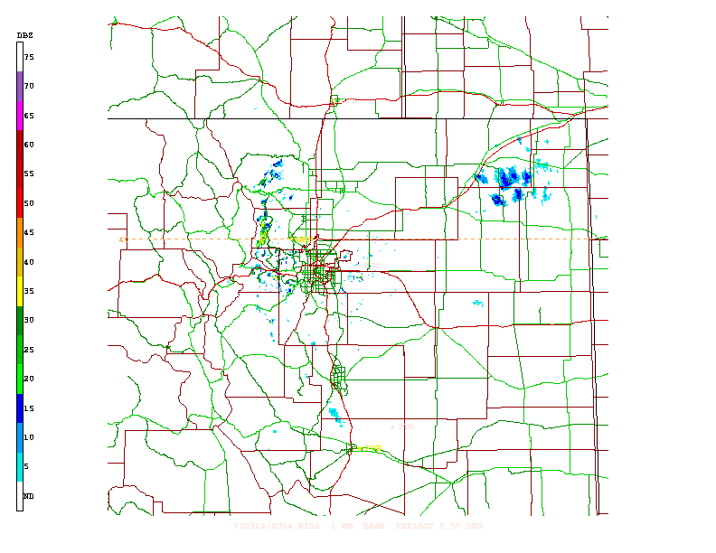
Hello David,

Yes, this should all be quite do-able..

I have one main question:

Are you running GEMPAK?

and if not, are you willing to load?

This would allow you the easiest method of generating "AWIPS-like"
imagery.

I have attached a sample .gif of a N0R tilt from FTG (the front range
radar) generated via GEMPAK..

There is no Boulder radar...but Pueblo,Cheyenne, and Goodland
exist..Boulder uses FTG.

Let me know if this is close to what you have in mind.

Many features that are available (streets, cities, counties, rivers) are
not all included in this image, but is user configurable.

Also, since it goes first to postscript the background is white, the
default for the comp screen is a black background..

This will allow me some info on how best to proceed with getting you the
data in a useable format..

Thank you,

-Jeff
____________________________                  _____________________
Jeff Weber                                    address@hidden
Unidata Support                               PH:303-497-8676
COMET Case Study Library                      FX:303-497-8690
University Corp for Atmospheric Research      3300 Mitchell Ln
http://www.unidata.ucar.edu/staff/jweber      Boulder,Co 80307-3000
________________________________________      ______________________
>
> Rob,
>
> I was given your name by Bob Lipschutz at FSL. I am with ETL in NOAA. We have
> a
> project with the Boulder, Pueblo and Goodland NWS offices to use Infrasound to
> detect tornados for the 2003 severe storm season. There will be an infrasound
> detection system at each site (BAO tower for Boulder). The idea is to have the
> local Nexrad 0.5 deg plot with county/state boarders and the direction from
> the
> infrasound site to detected sounds overlaid. These plots will be available at
> the three NWS sites via the Web. The plots will be evaluated to see if they
> can
> help in detection of tornados when they are still in the early stages of
> forming
> and hence have a longer forecast time.
>
> I worked with Bob to get Level 3 Nexrad data from FSL, but found out that FSL
> uses Level 2 data and just has some Level 3 data. I have looked at the Unidata
> site on "How to get NOAAPORT NEXRAD data via LDM" and on pages about the types
> of products available. I think I would like to get the PNG images of the 0.5
> deg
> reflectivity for each of the three sites. The image needs to 'look like' what
> a
> forecaster sees on the AWIPS screen, so that there is no mental 'translation'
> of
> the images seen on the two screens.
>
> However, if you suggest getting the data itself and doing our own plots so
> that
> we have more flexibility in generating an 'AWIPS' like plot, can you point me
> to
> a decoder to read the data and any code (C, Java, IDL) that would generate the
> needed plot?
>
> In either case can you point me in the direction of the person I should
> contact
> to get the Level 3 Nexrad data sent to us via LDM? The computer is:
>
>  Name:   brainiac.etl.noaa.gov
>  Address: 140.172.32.16
>
> This computer is currently receiving GOES data via LDM from FSL. Because of
> security, our network admin would need the IP address of the server so the
> router and TCP/IP wrappers can be configured correctly. Also, it would be
> helpful if the ldmd.conf request line and the pqact.conf action line could be
> supplied. We would want stations are KBOU, KPUB, KGLD, and KCYS.
>
> Thanks for your time and help.
>
> --
> David C. Welsh
> US DoC, NOAA MC R/ET
> 325 Broadway
>
> O (303) 497-6510  F (303) 497-6978
> http://www.etl.noaa.gov
>
Attachment:
FTG_radar_.50.gif
Description: sample