
This archive contains answers to questions sent to Unidata support through mid-2025. Note that the archive is no longer being updated. We provide the archive for reference; many of the answers presented here remain technically correct, even if somewhat outdated. For the most up-to-date information on the use of NSF Unidata software and data services, please consult the Software Documentation first.
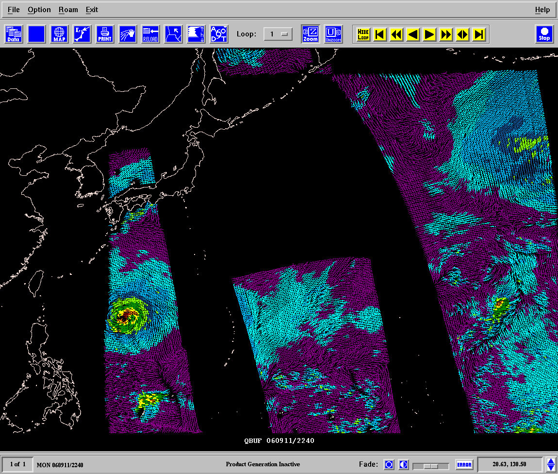
Quang,

The user support archives are not the same as a forum, so a followup to
a previous message from another user is a unique support ticket as you have
done.

In the future, we are planning to provide a forum interface to messages similar
to the
gembud email list at present.

The QuikScat data in BUFR data on the NOAAPORT data feed that we provide via
the IDD
only is available east of 130E, so your GAREA will not have any coverage. The
data
are those provided by NOAA for NOAAPORT. Unidata does not determine the region
of coverage that they provide for this dataset.

To plot the QBUF data, your file must be in the location referenced by the QBUF
template in datatype.tbl. This is not the location in SATFIL for GPMAP. The
SATFIL file is a parameter for an image where PROJ=sat. The bufr quickscat data
is not image, butr rather point data.

The QBUF entry I provide in datatype.tbl expects that your data will be stored
in the
directory $GEMDATA/qsct, and you files will be named according to the convention
YYYYMMDDHH.bufr. This is the location that will be used by the QBUF data type
in the GPMAP QSCT parameter line that you show below.

I have attached a tar file of recent qsct bufr files from the IDD, which
are in my $GEMDATA/qsct directory. I have also attached a screen shot of NMAP2
(which you can use as well as GPMAP to look at the data)

Steve Chiswell
Unidata User Support

> Dear All,
>
> I've readed the email "20050319: QuickScat data for
> Vietnam" on gempak's email.
> I have several questions about it.
> 01. How can I post/reply a new message in this mailing
> list?
> 02. I would like to ask Dr. Steve Chiswell about the
> QuickScat data for Vietnam. It seems that Mrs. Mai has
> asked this kind of question but till now, I can not
> view any QuickScat picture in NAWIPS system as well as
> in GPMAP utility.
> I've checked the params to configure LMD to store
> QuickScat BUFR as well as set the GEMPAK file template
> (all of those in
> http://www.unidata.ucar.edu/software/gempak/examples/QuikSCAT/index.html
> )
> . Although everything is like as the above guide, I
> can  see nothing except region's map.
>
> What happen with NMAP2? I show you the params in using
> GPMAP:
>
> MAP=1
> GAREA=-10;80;30;130
> PROJ=MER
> SATFIL=QS_XWGRD3_2006246.20062481508
> PANEL=0
> TITLE=1
> TEXT=1
> CLEAR=YES
> DEVICE=XW
> LINE=3
> QSCT=qbuf|last|6;12;18;24;30;36;42;48;54;60|30;6;26;24;21;23;5;17;8;14|31;31;31;31;31;31;31;31;31;31|.2;.4;1;5|0|1|1|Y|Y|Y|Y|Y
>
> but the result is the same.
>
> Please help me out, Dr. Steve Chiswell.
> At the moment, I would like to have a good example for
> GPMAP's params to display a QuickScat file. Could you
> give me those( GPMAP's params and one QuickScat file)
>
> Many thanks from you
> With my best regards
> Nguyen Dang Quang
> Dept. of Research and Application
> Vietnam national Center for Hydrometeorlogical
> Forecast
> 4 Dang Thai Than, hanoi, VIETNAM
> Tel.: 84-4-9330942
>
>
> __________________________________________________
> Do You Yahoo!?
> Tired of spam?  Yahoo! Mail has the best spam protection around
> http://mail.yahoo.com
>
>


Ticket Details
===================
Ticket ID: CPK-151666
Department: Support GEMPAK
Priority: Normal
Status: Closed
Attachment:
qsct.gif
Description: GIF image